FNT Software Releases GeoMaps 4.1 with New 3D Visualization for Enhanced Cable and Outside Plant Management
With Location-Based Visualization and Geo-Referenced Network Resource Analysis, FNT GeoMaps Provides Greater Visibility into Network Infrastructrure
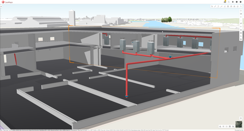
Short Hills, N. J. (March 16, 2023) – FNT Software, a leading provider of software solutions for the integrated management of IT, data center, and telecommunication infrastructures worldwide, today released a new version of FNT GeoMaps, a Geo-Intelligent component within its Cable and Outside Plant Management solution. Powered by Esri ArcGIS, FNT GeoMaps provides advanced geographic features that enhance the planning, operation, and management of passive inside and outside plant infrastructure with spatial intelligence. FNT GeoMaps 4.1 now provides in-house 3D views for cable management, enabling users to visualize where cables and other passive equipment are within a building.
The new 3D view functionality is an enhancement to the digital twin of network infrastructure and provides a unique view that supports the end-to-end management of cable and network infrastructure inside, outside, and between buildings. FNT GeoMaps now displays infrastructure assets on floor plans according to their location and height, and features seamless navigation between inside and outside infrastructure where 2D and 3D models show precisely where infrastructure objects are located by building and floor layer. The combination of GeoMaps and in-house DCIM tools with 2D/3D view capabilities give organizations a complete view of the network, from the outside plant to racks in the data center. The new visualizations enable users to zoom into floors and rooms where infrastructure objects are displayed, edit objects on floor plans, and filter data by building or floor layer.
“As Digital Transformation initiatives accelerate across all industries, it becomes just as important to have access to detailed location information about the cable and network infrastructure inside buildings as well as outside,” said Carsten Wreth, CEO of FNT. “We’re proud to offer 3D visualization within FNT GeoMaps 4.1 as this allows users to see exactly where cables and other passive infrastructure are located within a building, which gives them the ability to realize end-to-end management of cable and network infrastructure. By expanding the application of location intelligence with network infrastructure details in this way, our customers can make smarter decisions about network capacity, rollout priority and routing redundancy, and set the right focus for the operational priorities.”
FNT’s Cable and Outside Plant Management solution provides greater visibility into all network resources and connections to streamline the documentation, planning and management of inside and outside plant cable network infrastructure. From a service assurance perspective, this is the best defense against service interruption. From a planning perspective, it ensures that changes are based on accurate as-built documentation and that all changes are reflected in a master data repository.
FNT GeoMaps can be used in the network, data center and enterprise IT environments for georeferenced planning of network infrastructure, to support operational tasks with location intelligence, simplify complex capacity management use cases, and manage locations with their connection details. It is a fully integrated solution component within the FNT Command Platform. As such, it is part of FNT’s unified resource repository that documents and manages traditional active and passive telecommunication infrastructure, both on the physical and logical layers, as well as across the virtualized IT and data center resources. FNT solutions combine to form a central system of record for a holistic, vendor-agnostic solution that contains all relevant information for managing all IT resources and infrastructures, across all technologies. The combination of schematic views and GIS-based geographical network visualization of network resources provides greater visibility and location-based analytics for the improved capacity management, planning and operational use cases based on accurate data.
To learn more about FNT GeoMaps, visit: https://www.fntsoftware.com/en/use-cases/telco/cable-and-outside-plant-management/fnt-geomaps-for-cable-and-outside-plant-management
About FNT Software
FNT is a leading provider of software solutions for the integrated management of telecommunications, IT and data center infrastructure. FNT’s solutions are cloud ready and can be used worldwide as an OSS/IT management application for communications service providers, enterprises and government organizations. Over 500 companies and public authorities rely on FNT to plan, document and manage their passive and active physical, logical and virtual IT, telecommunications and data center infrastructures, from the physical level to business services. FNT’s unified resource management capabilities store this information in a vendor-agnostic uniform data model that builds a central system of record of a hybrid infrastructure. Whatever mixture of traditional on-premise IT and private, managed and public clouds an organization uses, the single source of information about all network assets that FNT provides is the key to gaining a clear understanding of overall utilization, capacities and asset status for more efficient planning, service assurance and fulfillment processes.
FNT is headquartered in Germany and has offices in the USA, Singapore, and the UK. FNT offers its software in numerous countries through partnerships with market-leading IT service providers and system integrators. Further information can be found at www.fntsoftware.com.
Agency Contacts:
Domenick Cilea
Springboard Public Relations
Dcilea@springboardpr.com
+1 732-813-7401
Caroline Smith
Springboard Public Relations
caroline.smith@springboardpr.com
+1 732-813-7402

